With the rapid rise of the low-altitude economy, unmanned aerial vehicles (UAVs, or drones) have been widely adopted across key sectors including emergency rescue, urban governance, ecological monitoring and logistics distribution. As a vital driving force for industrial transformation and upgrading, drones power the high-quality development of the low-altitude economy. Meanwhile, prominent challenges stemming from unregulated drone operations have emerged: unauthorized flights disrupting airport operations, illegal incursions into restricted airspace, fragmented regulatory authority, and poor cross-departmental coordination. These issues severely disrupt normal airspace order, pose potential threats to public safety, and hinder the sound and orderly development of the low-altitude economy. Consequently, addressing bottlenecks in drone regulation and establishing a scientific, efficient governance system has become an urgent priority for the growth of the low-altitude economy.
To tackle the above challenges and meet the core demand for secure low-altitude economic development, we adopt the core philosophy of technology-enabled smart governance and collaborative joint management. We have built a full-process intelligent drone management and control system integrating routine administration, data supervision, and joint prevention and control. This system aims to achieve four objectives for low-altitude flights: manageable, controllable, traceable and usable, strike a precise balance between safety supervision and industrial growth, and deliver robust support for standardized, orderly development of the low-altitude economy.
Centered on the safety requirements of low-altitude economic development, the system breaks the limitations of traditional fragmented supervision models. Guided by four core tenets — full-chain coverage, intelligent operation, high inter-departmental synergy, and flexible scalability — it creates four distinctive strengths that resolve major pain points in current drone governance while accommodating future industrial upgrading, fostering a new ecosystem for full-domain drone regulation.
1. Full-Stack Integrated Architecture for Zero-Blind-Spot Supervision
Designed with a full-stack integrated framework, the system unifies core capabilities spanning hardware monitoring, software administration, data analytics and emergency response. It eliminates the need to interface with multiple disjointed supervision platforms, enabling closed-loop end-to-end governance covering UAV registration, flight mission approval, abnormal flight alerts, and cross-departmental emergency response. It thoroughly addresses the drawbacks of traditional supervision, including fragmentation, weak cross-module connectivity and incomplete coverage, delivering full low-altitude airspace coverage and full-life-cycle flight oversight.
2. Intelligent Algorithm Empowerment to Boost Prevention & Control Accuracy
Equipped with advanced UAV intelligent identification and trajectory prediction algorithms, the system integrates multiple technical modalities including radar monitoring, optoelectronic recognition, radio frequency detection and AI analytics. It rapidly and accurately identifies drone models, identity credentials and real-time flight status, distinguishes compliant flights from unauthorized operations, and predicts anomalous flight paths in advance. This realizes early detection, early warning and early intervention, drastically cutting manual supervision costs and significantly improving the precision and efficiency of low-altitude risk response.
3. Lightweight Operation & Maintenance for Controllable Implementation Costs
The system features a lightweight deployment model supporting flexible cloud-based and on-premises deployment to fit supervision demands of varying scales and administrative tiers. It incorporates simplified operation and maintenance workflows that eliminate reliance on dedicated technical teams, reducing ongoing operational expenses and staff training costs. This ensures long-term sustainable supervision and resolves grassroots pain points of high implementation costs, complex maintenance and barriers to on-site deployment.
4. Outstanding Scalability to Align with Future Development Needs
Reserved flexible functional expansion interfaces support a multi-dimensional data collection and analysis framework. New extended modules can be deployed on demand to match evolving low-altitude economic trends and regulatory requirements, such as dedicated logistics drone supervision, low-altitude air route planning, and ecological monitoring data analytics. In-depth algorithmic mining of airspace operation patterns and unauthorized flight trends delivers precise data insights for regulatory decision-making. The system enables one-time deployment with continuous iterative upgrades, fully adapting to the future liberalization of low-altitude airspace and large-scale drone commercialization.
1. Routine Administration Platform
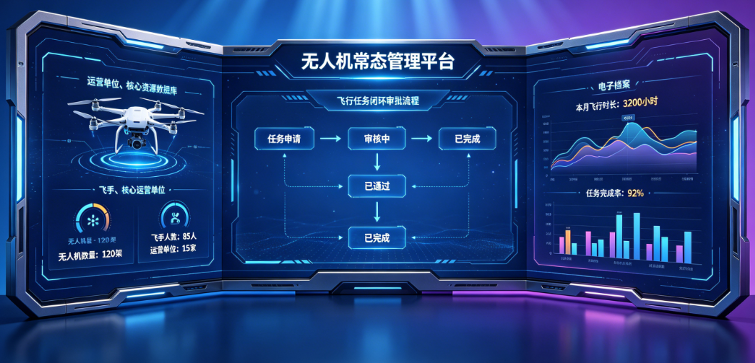
• Core Resource Database Establishment: Centralized databases covering three core categories — drones, pilots and operating entities — break cross-departmental and cross-regional data silos to realize unified aggregation and visualization of all resource information.
• Standardized Filing & Registration Workflows: Full-factor standardized registration protocols capture drone specifications, pilot qualifications, enterprise licenses and other credentials, with dynamic real-time updates to form complete, standardized electronic archives.
• Closed-Loop Approval Supervision: A unified approval workflow governs flight mission applications, registration information amendments and anomaly handling. Multi-level review and automated workflow routing enable full-life-cycle closed-loop management of flight operations, achieving unified cross-domain drone governance via a single integrated network.
2. Joint Prevention & Control Mechanism
• Cross-Departmental Data Interoperability: Standardized data exchange interfaces connect public security, emergency management, transportation, urban administration, ecology and environment, civil aviation and other key authorities, eliminating inter-departmental information barriers.
• Real-Time Information Sharing: Instant, second-level synchronization of core datasets including drone registration records, unauthorized flight logs, restricted airspace maps and emergency dispatch directives ensures seamless information exchange and efficient cross-agency collaboration.
• Strengthened Joint Response Capacity: Clear delineation of regulatory responsibilities and authority across departments underpins a unified command and scheduling platform. During emergencies, the system supports task assignment and resource allocation, activating multi-department joint response protocols for unauthorized flights, airport disruptions and other incidents to deliver rapid response, coordinated disposal and closed-loop case management.
• Automatic Multi-Source Data Collection: Real-time and historical datasets including flight trajectories, flight duration, altitude, pilot operation logs and enterprise compliance records are automatically aggregated from flight control systems, monitoring equipment and registration platforms.
• Unified Data Governance Standards: Standardized protocols govern data cleansing, conversion and integration to guarantee data accuracy, consistency and integrity as a foundation for subsequent analytical applications.
• In-Depth Data Analytics & Application: Algorithmic modeling analyzes airspace traffic, high-risk flight zones and violation trends to generate airspace operation status reports. Multi-dimensional visual dashboards and customizable data panels display core metrics for real-time monitoring of regulatory conditions, providing robust data support for airspace planning, risk forecasting and regulatory process optimization.
4. Prevention & Control System
• Three-Dimensional Monitoring Network Deployment: A space-ground integrated monitoring network combines radar, optoelectronic, radio frequency and AI analysis technologies to deliver full low-altitude coverage with intensified monitoring over key restricted zones.
• Accurate Identification & Dynamic Tracking: The system identifies drone models, identity information and compliance status in real time, continuously tracking flight trajectories, speed and heading to achieve full visibility and uninterrupted tracking of all regulated UAVs.
• Multi-Tier Early Warning & Disposal Mechanism: Automatic alerts trigger for unregistered flights, illegal incursions into core restricted zones and abnormal flight paths, triggering standardized cross-departmental response workflows. Authorized integrated interfaces support technical countermeasures and signal expulsion to effectively regulate unauthorized drones and safeguard airspace and public safety.
 Public Security Filing Number:辽公网安备21060302000305号


